Map 1866 Crown Street Main Street Sullart Street Gallowbarrow Railway NLS 229913847

Map 1866 Sullart Street Gallowbarrow Workhouse Gas Works CKPR Railway Christ Church
Click for zoomable map: https://maps.nls.uk/view/229913847
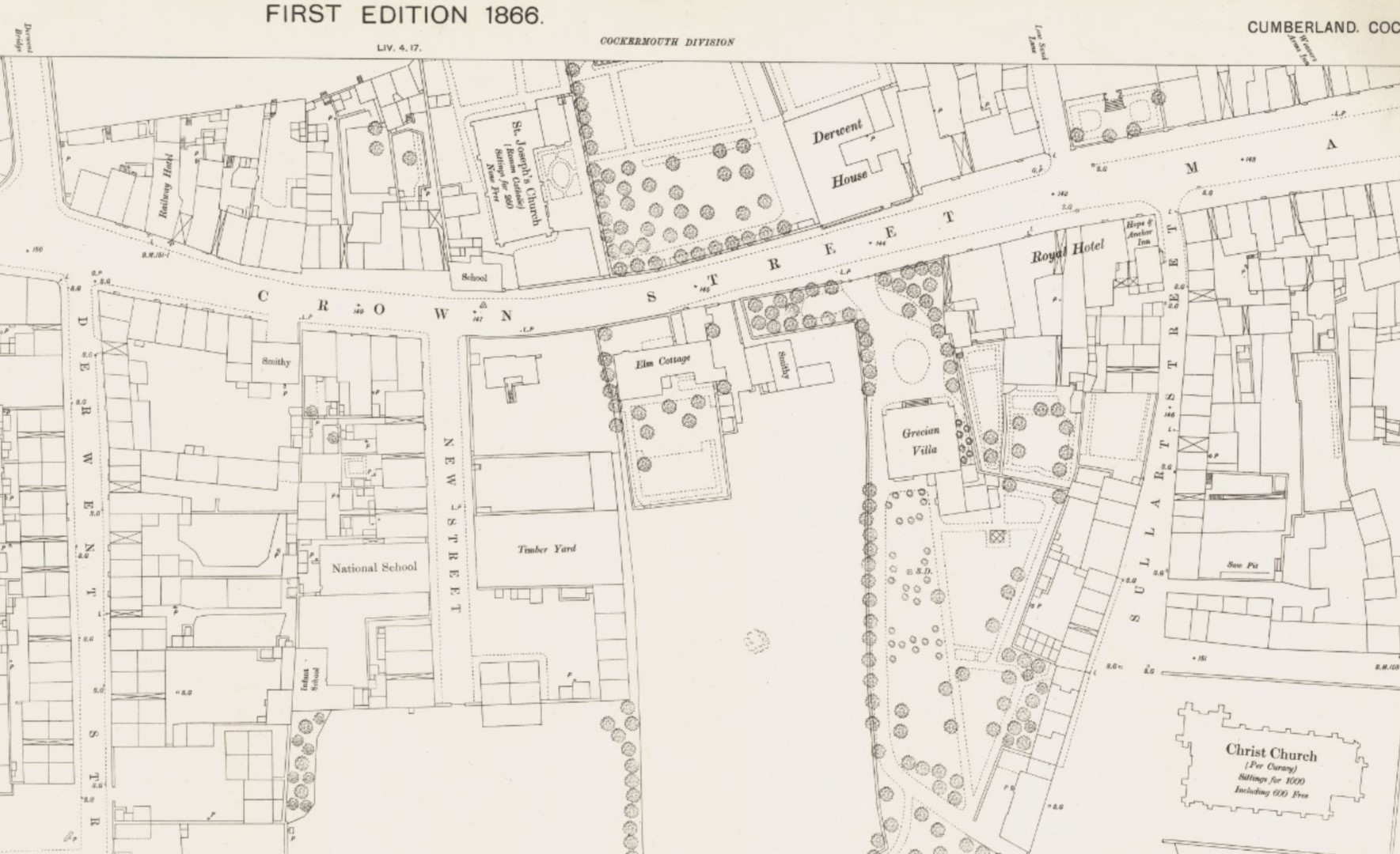
1866 map shows Gallowbarrow on the left and Sullart Street on the right but in later years the Ordnance Survey decided to swap them round so now Sullart Street goes on the left to todays car park, where the map shows the railway line, and Gallowbarrow now goes on the right. where once there was a bridge over the railway but is now filled in at the end of the recycling bins area. Between those roads is the Cockermouth Union Workhouse with their communal drying ground. Elsewhere on this website a photo shows the horse sales on Fairfield, where Sainsbury car park is now, and in the background beyond the communal drying area of Fairfield you can see the buildings of the Workhouse. Above and below the workhouse are four troughs which would provide water for drinking and for washing clothes which would be hung on the Drying Ground. In living memory in Cumberland we observed and experienced shared outside toilets and shared cold water washroom and laundry facilities. Our house still has the external washing shed with set pot and a fire under it to heat water for washing clothes. On the left of Gallowbarrow below the railway were the gardens for the workhouse, later became allotments, then County Council depot and now Woodville Park housing estate.
The Cockermouth Keswick & Penrith Railway (CK&P) line branches from the original Workington to Cockermouth line approximately where the storage units are on Low Road. The first railway line terminated at Cockermouth where Lakes Home Centre is now, and passenger could walk along to the Railway Hotel by Derwent (Gote) Bridge, note the various photos of the Railway Hotel with the arched entrance probably for horse and carriages. The CK&P railway carried from the northeast coal mines the special type of coal that can be turned into the type of coke required in iron making in West Cumberland. The first gasometer existed before the railway and at this time there is no siding to offload coal for coal gas making but more information is required.
Map 1866 Crown Street Sullart Street Gallowbarrow railway
Click for zoomable map: https://maps.nls.uk/view/229913847
New Street has the National School which later became a training facility for Harris Mill. Opposite is a timber yard that photos show at various times of development and re-development. Elm Cottage is now Elm Tree Terrace. Note the Smithy in Crown Street that still has the steel disk in its cobbled courtyard. St Joseph’s Roman Catholic Church has sittings for 250 none free and a school that obstruct the pavement and photos show its original building with its gable end used to advertise the neighbouring garage; other photos show the modern building set back to widen the pavement. Derwent House is now The Trout Hotel and opposite is Grecian Villa apparently with extensive gardens.
The Royal Hotel that was closed and converted into the Royal Garage operated by Raymond Wild – see photos of Wild’s garage with a swing arm pump for fuel. (In Market place there was Ellwoods that had the lorry smashed into it and Gordon Dickson National Benzol again with swing arm pumps). The Royal Hotel became Royal Garage then Fletcher wine merchant then Times & Star office now dog grooming.
Opposite the Royal Hotel is Low Sand Lane that led to the bank of the river Derwent, but the only way to cross the river was by the road bridge Derwent Bridge. When the Harris family built Harris Mill (now called Millers) their workers wearing wooden clogs would clop over Derwent Gote Bridge and along to the factory. So the Harris family being altruistic (I think Quakers) demolished the Weavers Arms at the top of the map, and made New Street and built a small row of terraced houses for their workers and built a bridge over the Derwent which we now call Millers Bridge.
Sullart Street joins Crown Street at the Hope & Anchor Inn but pub names change and it was called the Wordsworth Tavern when it was demolished in 1965 so that the Sullart Street road junction could be widened (photos of the workmen in the casual demolition). The name Wordsworth Tavern was later adopted by the Appletree Inn and that building is now Wordsworth recruitment office.
Grecian Villa was built 1800s Thomas Wilson, who built the hat factory, as a private residence. Then Cockermouth Rural District Council, then County Council used it for Registry Office, then Cumberland Fire Service headquarters, then Magistrate’s Court, then empty, now converted to The Manor House Hotel and restaurant.
Note that the road at the front of Elm Cottage does not have a footpath, so in later years of traffic, there had to be a way to create a footpath, so part of Elm Cottage gardens were taken, and a high retaining wall keeps the front garden intact.
To the left of Elm Cottage the building has been demolished and a row of houses built.
On New Street is National School building until Lord Leconfield gave land in Kirkgate for All Saints School to be built around 1860s. The National School building then became a church, possibly a version of Methodists. The All Saints School eventually closed and the building was used as a community centre for scouts then became the Kirkgate Arts and Heritage location.
In New Street after the National School closed it was used as a training school for workers at Millers shoe factory (originally of Great Yarmouth). After Millars it was converted into private accommodation.
The Infant School history is unknown at present.
Note that Cockermouth gas works were well established in 1863.
Note in Sullart Street, below the houses in South Street is a Saw Pit that was used with a two person saw, often the smaller (child) in the pit pulls the saw down and the stronger adult above pulls it up – I was one of those children in the 1950s and you remember to keep your eyes closed and don’t push the saw up or it jams.
St Josephs Roman Catholic church In Crown Street has sittings for 250 none free. In Sullart Street Christ Church per Curacy Sittings for 1000 including 600 Free ie 400 people paid annually as regular congregation.
Cockermouth – Cumberland LIV.4.22 Surveyed: 1863, Published: 1866. Reprinted: 1903
https://maps.nls.uk/view/229913847
Reproduced with the permission of the National Library of Scotland visit https://maps.nls.uk/