Map 1863 Derwent Fitz Mill Goat Mills Lowther Arms Blackfriars Bridge NLS 121144250

Click for zoomable map: https://maps.nls.uk/view/121144250
At the narrow end of Lakes Home Centre car park is a track that goes down the left bank of the Derwent to the U bed of the Derwent which is the site of Fitz Mill (Flax). Today only rubble shows where it was. Bradbury notes that it was a textile mill from the early 1800s, it ceased towards the late 19th century and was demolished about 1980. The tail race of Fitz Mill leaves to the left with a footbridge over it. The Derwent has a Weir to raise the height of the river to flow along the mill race to power Fitz Mill. There are photos showing the construction of a concrete bell shape sluice to control the height of the Derwent to power Fitz Mill, and it was designed with a Salmon Leap to facilitate the migration of salmon upstream – the Derwent was a good salmon river in 1863.

The remains of Fitz Mill Weir and Salmon Leap can be seen on the right bank of the Derwent. Using Google maps aerial view and photos on this site. From Gote Road along the right bank of the Cocker past the fishing hut to large stone blocks now overgrown which is the remains of the Weir and Fish Pass (photos on this site). Floods once washed away the surface on the right bank and exposed the old refuse tip of Cockermouth, this is an overgrown and potentially risky area best explored on a map.
On the north bank is Goat Mills (Corn) that were powered by a mill race that came from a bend in the Derwent opposite the castle, its sluice gate still exists, and went under Millers footbridge to power Goat Mills, its waterwheel is now embedded by the wall of the renovated dwelling.
Low Gote Mill comprised two mills. During the last 300 years the two mills have variously been corn, various textiles or one of each. The Harris linen firm occupied one mill from about 1820 until 1847. [Bradbury] In 1834 the Harris family built what was known as Harris Mill but is now known as Derwent Mill (now converted to apartments). The Harris family extended their new Harris Mill in 1847 and moved out of Low Gote Mill. Low Gote Mill had originally two mill buildings but the lower one was demolished and the upper was converted into apartments which have the preserved water wheel on display.
On the other side of the Goat Brow Road is marked as Goat Mills (Corn) which is now known as High Gote Mill and the building remains at the entrance to Lawsons Haulage yard. To the right of the current entrance to Lawsons Haulage is the house dated 1802 but the mill is much earlier. There is a reference to the mill in 1786 [Bradbury p173] The mill was a normally a corn mill but at other times it was used as a textile mill, run by the Harkness family, and closed in 1969. There is a photo of a Harkness lorry outside this mill. The High Gote Mill was often known as the Harkness Mill because of the connection with the Harkness family. The Harkness family were millers of flour and grain, roasters of barley for brewing and suppliers of feeding stuff for cattle, sheep, pigs and poultry. This mill spanned the mill race and went under the main road.
The original footbridge over the Derwent was built by the Quaker Harris family to save their workers going the extra distance over Derwent/Gote road bridge after the Harris family had built Harris Mill. Harris Mill was eventually taken over by Millers of Yarmouth and so was renamed Millers and the footbridge, Harris Bridge, was renamed Millers Bridge.
On this map notice Blackfriars Bridge beside Goat Well above the Lowther Arms Inn at the end of Spital Ing Lane which crosses over Goat Dub. See Bradbury p174. Do you know why the lane is called Spital Ing Lane, or why the bridge was named Blackfriars Bridge?
Not shown on this map is a later building beside Goat Mills which pumped water from a borehole beside Derwent to a reservoir at the top of Tallentire Hill (still there) then the water flowed by gravity to supply drinking water to Maryport.

Click for zoomable map: https://maps.nls.uk/view/121144250
In 1863 there was no footbridge over the Derwent nor over the Cocker. What we now know as the United Reformed Church URC in Main Street was known as Independent Chapel (Calvinist) and in High Sand Lane what is now known as The Vicky business centre was Methodist Chapel (Primitive) which was a different branch to what is now the Town Hall which here is recognised as Methodist Chapel (Wesleyan).

Click for zoomable map: https://maps.nls.uk/view/121144250
The number of Inn locations on Main Street may reflect the uncertainty of safe drinking water before universal drinking water mains supply to individual homes.
Click for zoomable map: https://maps.nls.uk/view/121144250
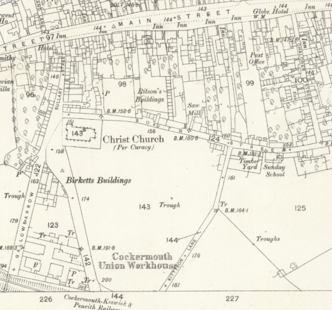
The new Cockermouth Keswick & Penrith Railway (CKPR) branches from the original Cockermouth & Workington Railway which terminated at where Lakes Home Centre is now. The CKPR skirts the Cockermouth Union Workhouse which had outside washing areas marked as Tr ie water troughs. On this map Gallowbarrow ends at the railway line which is today a car park with recycling bins. Here, Sullart Street crosses the railway on a road bridge, now filled in at the end of the Sullart Street car park. At the top end of Sullart Street you notice a long row of houses on the left and the road is very narrow as it meets the Crown Street Main Street junction. Note that those houses had no back yard and washing was done communally and drying was done on communal lines on the open area between Sullart Street and Kittyson Lane, where the car park above Sainsbury and the schools are now – see photos. Note that the names of Gallobarrow and Sullart Street were swapped after this map was made.
The new Cockermouth Railway Station is to the right of this map, but did you notice that there is no easy road from Main Street? This map allows us to see the changes to roads that were required but not yet carried out. Observe the Post Office is on a road that cannot get to South Street, it is blocked by houses, so eventually those houses are to be demolished and the new Station Street and Station Road will be built to give access to the new Railway Station near where 227 is shown on this map. Challoner Street will be relieved of two way horse drawn carts and buggies.
The railway line from Cockermouth to Keswick to Penrith was officially opened for goods (minerals) traffic on 1 November 1864 but not open for passengers until 2nd January 1865. See Wikipedia for more information, Cockermouth, Keswick and Penrith Railway – Wikipedia Those of us who use Wikipedia often donate to encourage its continuance.

Map 1864 Cockermouth Railway Station before Station Street and Station Road were built
(Above is a section from Map 1864 Cockermouth Brigham Broughton Eaglesfield Greysouthen Clifton Deanscales at https://maps.nls.uk/view/102340848 )

Map 1863 OS 25 inch before Victoria road bridge or South Street foot bridge over Cocker
Click for zoomable map: https://maps.nls.uk/view/121144250
Until Queen Victoria’s Jubilee there was no Victoria Terrace, no Victoria Bridge over the Cocker and the terrace of houses above Skinner Street were intact until some of them were demolished to make an access to the new elevated road to the right of Skinner Street that had been elevated to make a tunnel over the railway. There was no footbridge over the Cocker until the Quakers built the South Street / Quaker Bridge to ease access to their Friends Meeting House.
Cumberland LIV.4 Surveyed: 1863, Published: ca. 1866
https://maps.nls.uk/view/121144250
Reproduced with the permission of the National Library of Scotland visit https://maps.nls.uk/