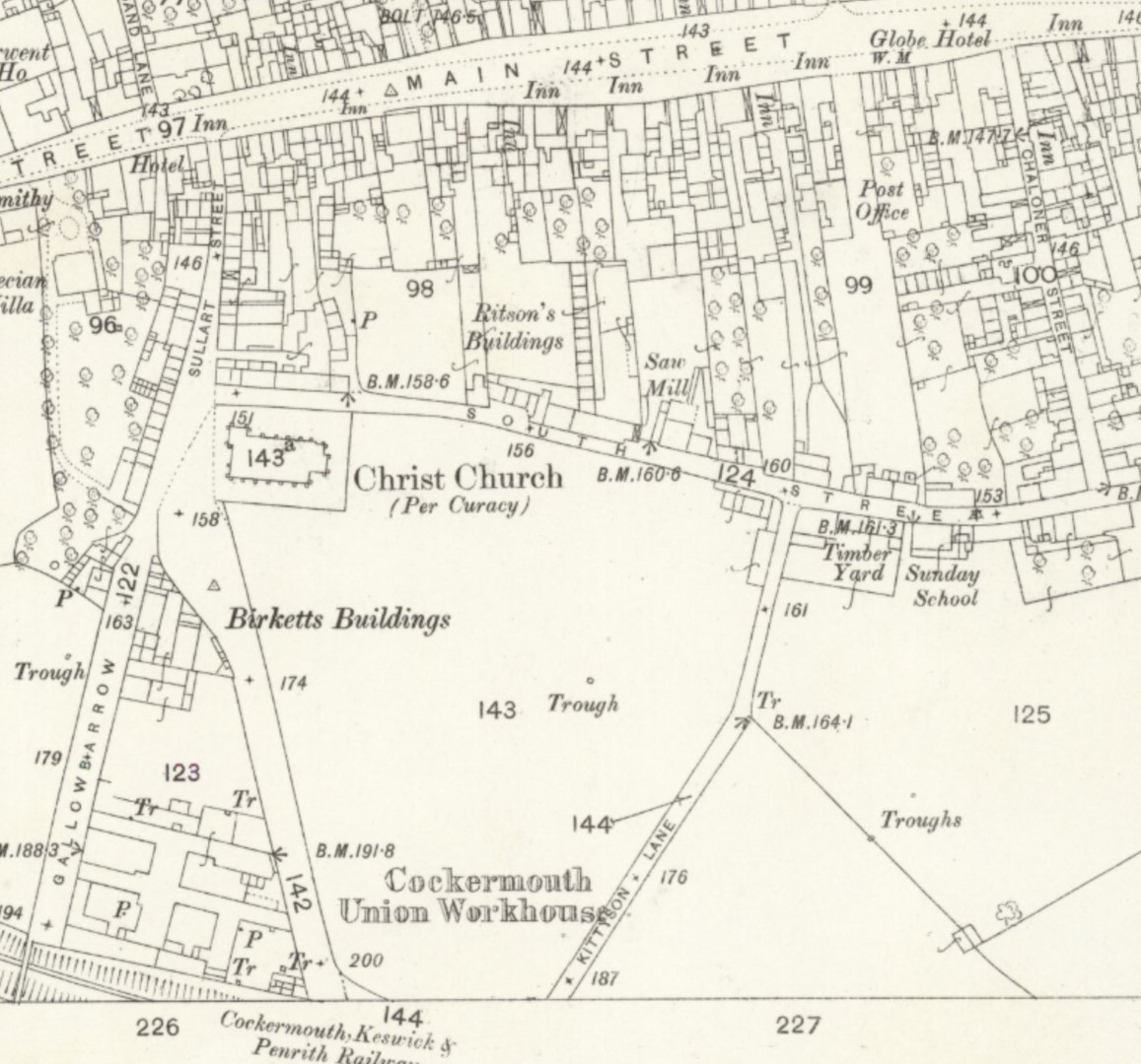
Cockermouth History
This small section shows the new Cockermouth Railway Station, but did you notice that there is no easy road from Main Street? This map allows us to see the changes to roads that were required but not yet carried out. Observe the Post Office is on a road that cannot get to South Street, it is blocked by houses, so eventually those houses are to be demolished and the new Station Street and Station Road will be built to give access to the new Railway Station near where 227 is shown on this map. Challoner Street will be relieved of two way horse drawn carts.
Map 1863 Workhouse Sullart Street Smithy Railway no Station Street NLS 121144250
Click for zoomable map: https://maps.nls.uk/view/121144250
The railway line from Cockermouth to Keswick to Penrith was officially opened for goods (minerals) traffic on 1 November 1864 but not open for passengers until 2nd January 1865. See Wikipedia for more information, Cockermouth, Keswick and Penrith Railway – Wikipedia Those of us who use Wikipedia often donate to encourage its continuance.
Map 1864 Cockermouth Railway Station before Station Street and Station Road were built NLS 102340848
Click for zoomable map: https://maps.nls.uk/view/102340848
Map 1864 Cockermouth Lower and Upper Railway Stations NLS 102340848
Click for zoomable map: https://maps.nls.uk/view/102340848
The first railway from Workington terminated at Cockermouth but a new railway was built from Cockermouth to Keswick to Penrith to join the rail network to the northeast over Stainmore to bring suitable coal to Workington to be made into coke to reduce iron ore by smelting into pig iron ingots which could be sent on the same line to the northeast via the Stainmore line. The railway was not originally built for passengers. Coal contains tar and other impurities and Cumberland coal was not suitable for making the coke that was to be used in the smelting of iron ore to make iron.
Cumberland Sheet LIV Surveyed: 1864, Published: 1867
https://maps.nls.uk/view/102340848
Reproduced with the permission of the National Library of Scotland visit https://maps.nls.uk/
Sources and thanks and permissions and copyright are shown on appropriate pages and/or in the About section. If someone can prove they have sole copyright and ownership of all rights to the negative and positive prints of a photo and its digital copy, and if they then want to have their name acknowledged after providing their clear evidence of ownership of sole copyright then I will acknowledge that right. Otherwise this personal project, made at my own expense, is my voluntary, free to access website made with goodwill to the community, so that the site gives free access to our community’s historic information. For those who desire to stop some photos being seen, review your motives; some photos were given to the local history centre and have been hidden for 20 years – why? I don’t have access to them. Surely when the community give photos to a local centre for free, the photos should be available to the public to view with free access and free sharing by digital reproduction on which we can add our own descriptions on our own websites and Facebook pages and other sharing sites? Please read the acknowledgements and thanks on the About section – there are some astounding links including the National Library of Scotland’s (NLS) zoomable historic maps, and sites of rail and coal historic sites and … see About. Perhaps the links will stimulate you to do your own research for your own personal education like this site that I made for personal research and education.