Press release: From:Environment Agency Published 12 January 2022
- Works have involved strengthening a 50m section of river side retaining wall.
- The Environment Agency are now planning for a permanent repair.
Emergency works on a river side retaining wall in Cockermouth have been completed, strengthening the existing flood defences during winter.
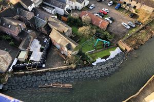
Following the wet weather on the 28th October 2021 and subsequent high-water levels on the River Cocker, approximately 50m of river side retaining wall fell into the river, leaving the foundations of the existing flood defence walls exposed. This did not increase flood risk to the community but left the defence susceptible to damage in future wet weather events.
Emergency works were carried out by Environment Agency contractors and involved the use of a crane to place stone bags in the river in front of the flood wall. This helps to prevent erosion and undermining of the wall during future high flows, ahead of any permanent works in future. A temporary flood defence has also been installed in the old police station yard.
Environment Agency’s Matt Crump, Operations Manager for Cumbria said:
“Wet weather on the 28th October last year gave us significant rainfall in a short period of time and our thoughts remain with those who may be still affected.
“After the flood water subsided, we inspected all of our assets and flood defences and quickly put plans in place to repair any damages. I am delighted to see that the initial works in Cockermouth have now been completed. This was a significant repair which has allowed us to strengthen the town’s flood defences while we explore more permanent solutions.”
“With winter upon us, I would also like to take the opportunity to highlight how vital it is that everyone knows how flooding can affect them and how to keep loved ones, property and possession safe. Go to the Gov.uk website or search ‘know my flood risk’ to sign up for Environment Agency flood warnings, receive information on the risk in your area and what to do in a flood.”
To keep up to date with Environment Agency’s work in the North West follow us on our Twitter account @EnvAgencyNW
Updates to this page
Published 12 January 2022