1900-1945 Main Street from Cocker Court House to High Sand Lane 02-42

1900-1945 Main Street Menu
Main Street Photo from about 1910 with cows being herded down Main Street by a lad. By the Neddy clock tower a horse and car is led up Station Street.
Horse and carts are the normal means of transport at this time, but the new transport of a motorised carriage is parked on the left with its high hood and another photo shows its single rear oil lamp that was ignited when required.
On the right is number 22 Derwent Temperace Hotel with the awning of Joshia Hall and his three storey warehouse doors to the left of the arched windows. He was a grocer and wholesaler.
Joshia Hall was a Quaker and was instrumental in getting the footbridge over the Cocker at the end of South Street; the bridge is still known locally as Quaker Bridge.
The sign above the arched door is “Derwent Temperance Hotel” and the Temperance may relate to Joshia Hall’s Quaker belief, though this is speculation.
In the centre is the clock tower built 1895 and the young trees plated in 1887.
Gas powered street lights illuminate the street, and had a bar sticking out to the side for the man to lean his ladder against to light the lamp and if necessary to replace the mesh that glowed with weak light when the gas was lit. The cast iron lamp stand was a favourite for kids to climb and try to swing on the bar – don’t try this today!
c 1910

Main Street April 11th 1917 in the snow. The photo is taken from Cocker Bridge and shows children pulling their hand cart in the days before motor vehicles were common. The trail in the snow is evidence of hoof marks, not tyres, and the exhaust from horses.
On the right is number 2, this was the imposing entrance was the entrance to Cockermouth’s first Savings Bank and is now Cartmell Shepherd.
On the left is the similarly imposing entrance to what is now the Club Derwent, the ex Conservative club. This building has a history worthy of more research and we have deeds of the building dating back to 1709 – get in touch if you want to do some research. See Main Street 01-35 1800-1899 – Cockermouth History
In the centre is the clock tower and beyond is Mayo. Photo has title Main St from Cocker Bridge April 11 1917

Main Street when motors replaced horses. On one side of the road is a heavily laden cart with a horse ready for its work. A handcart also awaits a person to trundle it to its destination.
On the other side of the road is a motor vehicle with the armchair comfort of its rear seat.
Note the road is smooth gravel, many years before tarmac, and note the smooth tyres, so the car driver has put chains around the smooth tyres for grip – tyres did not have the knobbly patterns for grip that we take for granted.
Also note the only rear light of the car is a lamp that will need to be lit and hopefully would not be blown out on the bumpy roads.
The clock tower locally known as “Neddy” was built in 1895 and demolished in 1932 because it was offset and thus a hazard to the new motorised traffic.
The car is registration number AO22 and AO is the registration for Cumberland, so this must be the 22nd car to be registered under AO.
On the right is Main Street 4 Savings Bank, number 6 was Allison grocer, not related to Allison Chemist.
c 1899 – 1910

Main Street number 2 is known as The Old Courthouse. The original courts were held in the Moot Hall in Market Place which was demolished in 1826 and the stone was reused to build The Old Courthouse.
The original bridge over the Cocker was low and narrow so after The Old Courthouse was built a new Cocker Bridge was built higher and wider in 1828.
The imposing set of steps to the entrance of the Courthouse was known by locals attending court as “Walking up the seven steps!”.
To the right of the steps on the wall is a plaque that came from the clock tower that had been erected at the junction of Main Street and Station Street in 1895. It had been erected in memory of Edward Waugh MP.
However, the clock tower was not in the centre of the road and though this may have been no problem in the days of horses and carts, it became an obstruction to motorised traffic (see the photo of the Rolls going round it the “wrong” way). So the clock tower was demolished in August 1932.
A commemorative metal plaque was put on the wall of the Old Courthouse and states:
“In memory of Edward Waugh Esquire, the last representative in Parliament of the ancient Borough of Cockermouth. Erected by subscription 1893”
Below it is a plaque explaining :
“The above plate was attached to the Edward Memorial Clock, removed from Main Street Aug 1932”
Various courts were held at The Old Courthouse 2 Main Street until moving in the early 1950s to the building that is now known as Manor House Hotel (was Grecian Villa etc).
The Old Courthouse, lay empty for several years, until in the 1970s it was converted into flats, shops, an antiques centre, and a restaurant that was accessed by descending to a cantilevered metal walkway suspended over the (sometimes raging) Cocker.
Now after recent floods in 2020s that suspended walkway has been demolished and part of the rear building has been swept into the river Cocker. Floods of the Cocker undermined the foundations of the building at the rear and the whole building is now closed and the rear section has collapsed.
On the far side of the bridge over the Cocker is the gable end of Huddarts shop advertising Three Castles with the wall descending to the edge of the river Cocker. In an earlier flood of the Cocker in the early 1900s the end of the shop was demolished, so today you will see a grassed area where once part of the shop stood. This photo circa 1930.

Main Street. The postcard of November 1903 shows the town in normal business. The hand cart on the right was used to deliver things, perhaps from Joshia Hall’s grocery and warehouse on the right. The number of horse drawn wagons have left their exhaust on the road.
The clock tower with four gas lamps and railings around it is offset to the right, so when motor vehicles became common the tower became an obstruction and was removed.

Main Street 37 Brown Cow at the bottom of Station Street. The clock tower with its railings and lights with lots of children in plus fours posing for the camera, which would be a plate glass camera requiring a long shutter opening, so posing was required or the people would be blurred. Note the horse with a heavily laden cart, but note the horse “exhaust” droppings in the road.. c 1899

Main Street clock tower gas lamps old cars.
On the skyline at the right of the photo is the Savings Bank clock above what was the original Trustees Savings Bank that was built in 1846. The clock had been made by Cockermouth clock maker Christopher Tatham.
Note to the right of the clock tower is a white car with a rounded rear; this rounded rear was the cover for what was known as a “Dickie seat” where the lid opened and the open seat was behind the driver. c 1929

Main Street 22 grocer is now Tarantella restaurant.
The three storey building still has warehouse doors to the left of the arched windows and was originally Joshia Hall grocers. Hall was a Quaker and was instrumental in getting the footbridge over the Cocker at the end of South Street and the bridge is still known locally as Quaker Bridge.
Before the bridge there was only a ford – see picture taken from Victoria Jubilee Bridge – there is a commemorative plaque in the centre of Jubilee Bridge.

Main Street 22 Josiah Hall Family Grocer and High class Italian Warehouseman. Teas of finest quality; Coffees roasted freshly on the premises by newest machinery. Agent for Huntley & Palmers Biscuits; Harris Bacon; Chivers jams jellies.
Hall was a Quaker and was instrumental in getting the footbridge over the Cocker at the end of South Street and the bridge is still known locally as Quaker Bridge. Before the bridge there was only a ford – see picture taken from Victoria Jubilee Bridge you can still see the commemorative plaque in the centre of Jubilee Bridge. From an advert 1906

Main Street flood 1931
On the left is number 56 before it was demolished and a new building built for Boots Chemist.
Note the clock above the Savings Bank which is now Cartmell Shepherd Solicitors.
Note the street light and the lights above the shop are gas lamps that used the town gas that was produced in the gas works and the gasometers at the top of Derwent Street. The lights did not simply illuminate with a switch! The gas had to be ignited by turning the supply on, then a person with an ignited flame on the end of a pole had to put the flame next to the gas that was now coming from the lamp so it ignited. The flame was not enough illumination without a special gauze called the gas mantle which had to be replaced frequently. There were many fires and even explosions caused by gas leakages. This is the flood 1931
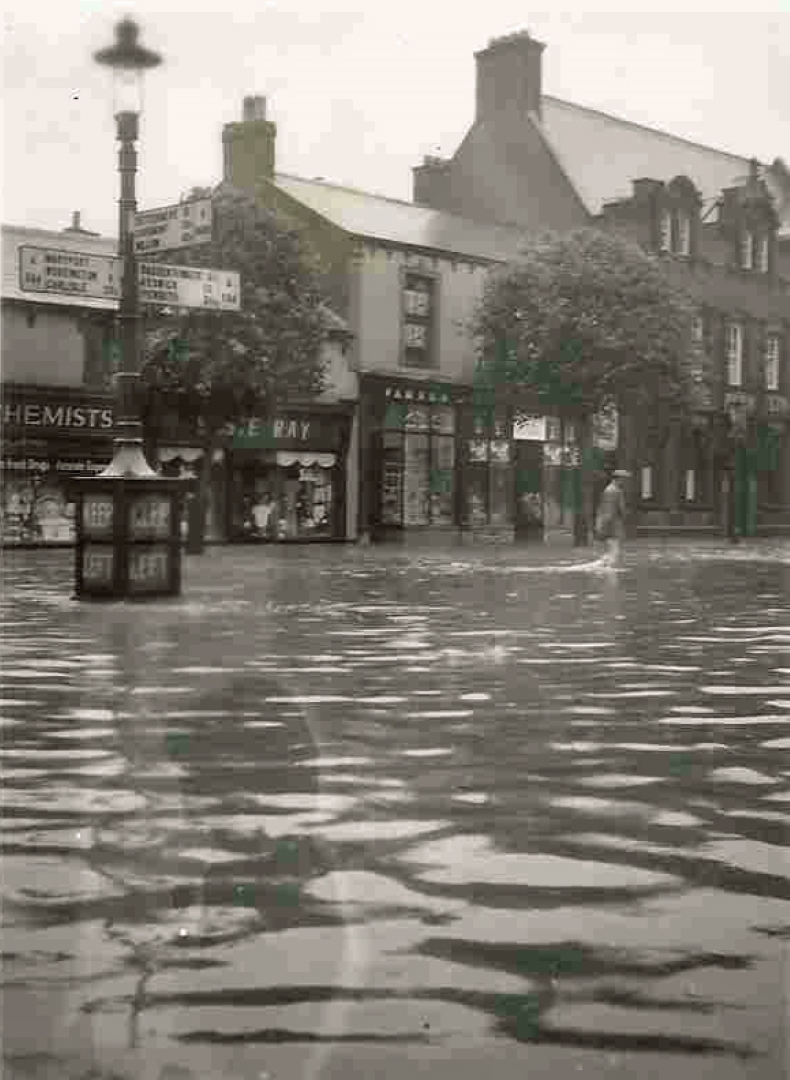
Main Street. Behind the man wading in the flood is a shop adjacent to Martins Bank which became Barclays Bank but now is also closed.
To the left of the bank is Walter Wilson’s first shop in Cockermouth before expanding left and later moving to Lowther Went before closing and that premises became Wilko which also recently closed.
Number 38 is Parker stationery; 40 Elsie Ray; 42 Timothy Whites Chemist (now the New Bookshop).
Note the road sign in the flood. To the right is the only road to Keswick and Penrith, going up the narrow Castlegate. To the right the signpost is to Buttermere and Millom.
Date worked out because in August 1932 the clock tower was removed because it was a traffic obstruction, replaced with this signpost , so this is winter of 1932

Main Street 42 Taylors Chemist is now New Bookshop 40 Elsie Ray clothing. Note the signpost is now substantial because the flood of 1932 washed away the temporary signpost. Flood 1938
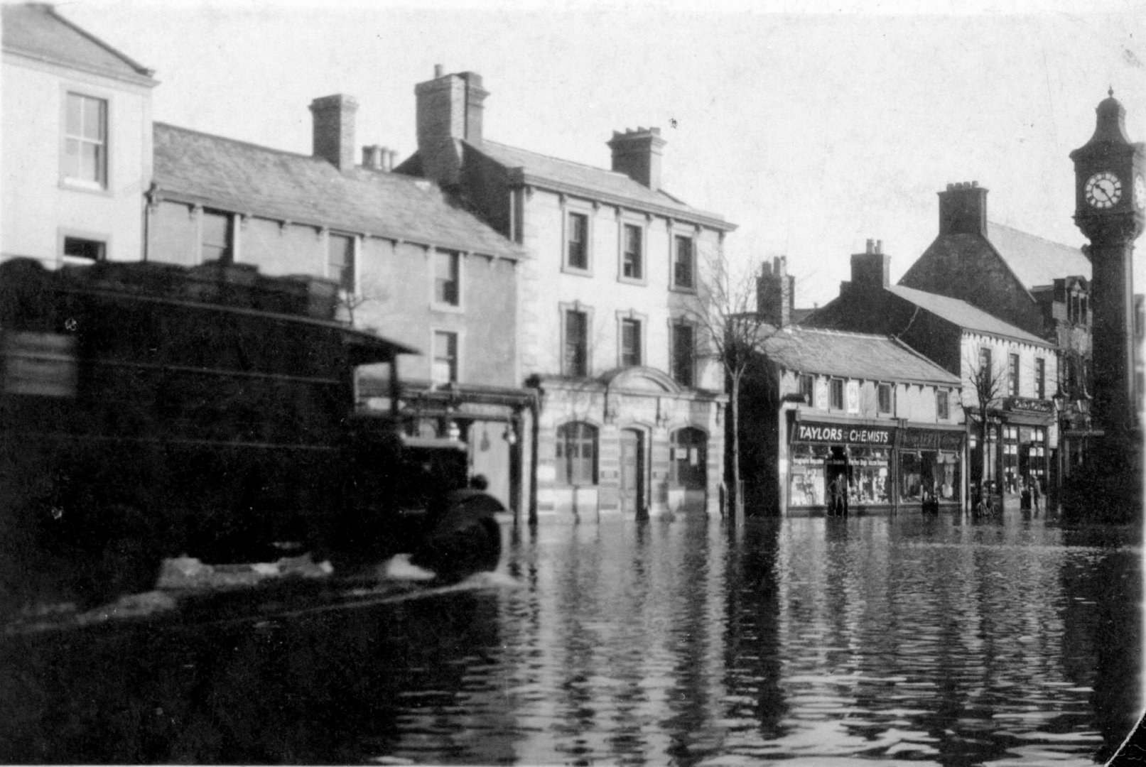
Main Street 42 Taylors Chemist 44 National Provincial Bank Clock tower flood 1918

Main Street. To date this flood, note the removal of the clock tower was in August 1932 and a temporary road sign of a wooden finger post was put where the stanchions in the road are in this photo, and the flood washed the temporary wooden sign away as shown in the photo
Number 42 is Taylors chemist before it became Timothy Whites then New Bookshop ; High Sand Lane; 44 National Provincial Bank became various shops numbered 46; 46 Martins baker became 48 Fish chips; TSB now 50 Waugh & Musgrave; 48 Irving became Oak Tree charity; 54 Harris Ward became Greggs baker; 52 Rydiard and 54 Miss Straughton. : Main Street 37 Brown Cow Hotel. After 1932

Main Street Elsie Ray’s who won shop window display 1937 for Daily Mail so pre 1937 now Grisedales was Bryden Fancywear shop for ladies. 1937

Main Street 40 Elsie Ray ladies clothing Coronation of King George VI 1937 wins Daily Mail window display detail now Grizedale 1937

Main Street Bryden Fancywear shop for ladies (now Grisedales) became Elsie Ray’s who won shop window display 1937 for Daily Mail so pre 1937

Main Street 12 Fletcher outfitter now Tony Marks. Next door was 14 Fletcher ladies clothing now Rootz ladies hairdressers. To the right was the former police station. Fletcher gents outfitter was the Cockermouth Grammar School supplier of uniforms. c 1939

Main Street 16 was The Cosy Tea Rooms upstairs from the entrance to the left of the archway that leads to the large space behind
Main Street 18 was Fidlers Temperance Hotel, advertised in the Harmonics Diamond Jubilee concert 1914. Number 18 is advertised as Fidlers Temperance Hotel but Fidler shop was a printer but ceased in the late 1890s. The building became part of the Grasmoor Hotel and number 20 was the Derwent Hotel. In 1947 they were combined into a 26 bedroom Grasmoor Temperance Hotel and they also absorbed the shop across the passageway at number 16 that became the Grasmoor Tea Rooms.
The early trees possibly earlier than our estimate of this photo being c 1920

Main Street taken from the junction with Station Street.
The imposing front of number 30 was Martins Bank now Barclays Bank (now closed).
On the far right of the row where the photo is smudged, was the Horse and Harness pub which has been demolished and the new police station built and is set back from the Main Street.
To the left is the Grasmoor Hotel and then the three storey warehouse doors of Bewsher grocer. The road continues right to Cocker bridge viewed here from Station Street c 1920 p2