Kirkgate bridge over Bitter Beck. Today, stand on the bridge over Bitter Bech and see gardens on the left where these houses were. The row of houses was rebuilt further back from Bitter Beck. The house on the far left was demolished and now you see the gable end of the house that makes the narrow entrance to Kirkgate. Note on the right hand side the congested houses and buildings that were around the Kirkgate Centre building and were all demolished.
Streets Menu
Click a pic for slideshow (Esc returns to this screen)
Kirkgate bridge over Bitter Beck. Today, stand on the bridge over Bitter Bech and see gardens on the left where these houses were. The row of houses was rebuilt further back from Bitter Beck. The house on the far left was demolished and now you see the gable end of the house that makes the narrow entrance to Kirkgate. Note on the right hand side the congested houses and buildings that were around the Kirkgate Centre building and were all demolished.
Kirkgate 1 entrance from Market Place when the fair closed Main Street to traffic double decker busses came down here. The gable end on the left is regularly damaged. Observe the end wall, it has a door and step but to its right are the tops of windows that at one time extended lower down when the road was at a much lower height to cross Bitter Beck. Other photos show the regular flooding of Bitter Beck so it was sensible to raise the height of the road, but the raised road covered the lower part of the window and the door that had been at ground level was submerged under the road and is now blocked off and the adjacent steps removed. . Kirkgate road used to go down to a ford that crossed Bitter Beck to enter Market Place. Then a bridge was built over Bitter Beck, but it would have been a steep humpback bridge so the road from Kirkgate was raised to make a smooth entrace to Market place, but the raising of the road meant that some of the houses were now below the road level. c 1950
Kirkgate crossing the Bitter Beck. In the foreground. The houses that were on the right are demolished and only the edge of Beck Cottage is shown, adjacent to the Bitter End. The entrance to the Kirkgate car park will later be on the right. c 1950
Kirkgate 15 Bitter End pub 17 19 23 from All Saints Church tower c 1990
Kirkgate Rope Walk now demolished accessed from bottom of Kirkgate cobbles Kirkgate car park is below on the left c 1950
Kirkgate former grocers shop run by the Martin family for many years.
Kirkgate 36 shop of Martin Distinguished Conduct Medal 1916 for Lance Corporal Martin photo c 1916
Kirkgate 1 entrance from Market Place when the fair closed Main Street to traffic double decker busses came down here. The gable end on the left is regularly damaged. Observe the end wall, it has a door and step but to its right are the tops of windows that at one time extended lower down when the road was at a much lower height to cross Bitter Beck. Other photos show the regular flooding of Bitter Beck so it was sensible to raise the height of the road, but the raised road covered the lower part of the window on the left.
Kirkgate 1 entrance from Market Place when the fair closed Main Street to traffic double decker busses came down here. Observe the end wall, it has a door and step but to its right are the tops of windows that at one time extended lower down when the road was at a much lower height to cross Bitter Beck. Other photos show the regular flooding of Bitter Beck so it was sensible to raise the height of the road, but the raised road covered the lower part of the window on the left. . Kirkgate road used to go down to a ford that crossed Bitter Beck to enter Market Place. Then a bridge was built over Bitter Beck, but it would have been a steep humpback bridge so the road from Kirkgate was raised to make a smooth entrace to Market place, but the raising of the road meant that some of the houses were now below the road level. c 1950 LEAD Technologies Inc. V1.01
Kirkgate lower section now demolished. Kirkgate road used to go down to a ford that crossed Bitter Beck to enter Market Place. Then a bridge was built over Bitter Beck, but it would have been a steep humpback bridge so the road from Kirkgate was raised to make a smooth entrace to Market place, but the raising of the road meant that some of the houses were now below the road level. This picture shows the extreme inconvenience of the ground level. Both of these houses were eventually demolished to make access for the Kirkgate building which was a school then the athletics club then the arts centre. c 1950 p3
Kirkgate lower section now demolished. Kirkgate road used to go down to a ford that crossed Bitter Beck to enter Market Place. Then a bridge was built over Bitter Beck, but it would have been a steep humpback bridge so the road from Kirkgate was raised to make a smooth entrace to Market place, but the raising of the road meant that some of the houses were now below the road level. This picture shows the extreme inconvenience of the ground level. Both of these houses were eventually demolished to make access for the Kirkgate building which was a school then the athletics club then the arts and heritage centre. The white building is the second entrance to the Bitter End and its shaped windows are still seen today. c 1950
Kirkgate 1731 cottage which is left of Bitter End pub Kirkgate Centre behind. c 1950
Kirkgate lower section before demolition for Kirkgate car park. The white building 1731 Beck Cottage remains adjacent to the Bitter End. The grey building in the centre was demolished to make the entrance to the Kirkgate car park with other photos showing this was a three storey building with the lower storey under the height of the road because the road was raised to stop Bitter Beck flooding it.. The metal gate between the buildings was the entrance to the All Saints School that was in the building that became the Kirkgate Arts snd Heritage Centre. c 1950
Kirkgate 15 Bitter End aerial view c 1980
The 1770/71 map of Cockermouth shows that there was a building in existence at this position but it gives no indication of building type. The current form is not original and is probably a late Victorian makeover of that original building. The wide windows without structural mullions places it 1860 onwards but the lower splayed wall on the right hand bottom corner suggest something earlier and of a more utilitarian building which may have been a barn, warehouse or shop. According to Bradbury, it has been used as an early coffee house.
The building stands out as different from the attached cottages on either side of it. A good example of how buildings have evolved over the centuries. c 2020
Kirkgate 22 was an early coffee house according to Bernard Bradbury
Kirkgage 31 and Slatefell estate from All Saints Church spire. On the left, the white corner building was the home of George Cockton who had Cockton’s shoe shop on Main Street that had a prominent sign that can be seen in the photo of the erection of the Mayo statue in 1875. The yards behind shops were named after the significant shop at the front, in this way Cockton’s Yard became named and later renovated to its award winning present day – The Hidden Terrace – accessed from the door beside PFK / Brysons and from Waterloo Street. c 1960 p3
Kirkgate Rope Walk now demolished accessed from bottom of Kirkgate cobbles the roof of the athletics building (now demolished) on left, now the Kirkgate car park c 1950
Kirkgate 36 shop was originally Martins grocer then craft shop then cafe note Chestnut tree was disease so felled
Kirkgate 36 shows sign for Martins grocer shop before it became Johnty coffee shop with chestnut tree that became diseased and felled c 1950
Kirkgate 36 with Martins grocer shop on right note no yellow lines so c 1950
Kirkgate 4 Slaters Chippy below All Saints walls building now demolished. This photo came from the Slater family and shows the previous generation of family. c 1890
Kirkgate cobbles. Kirkgate that we see today is mostly Georgian architecture with some date stones of 1729 and 1731 on buildings. The cobbled are was built before the days of tarmac and concrete paving and in the time when horses were the transport available. Cobbles are hard wearing and the rounded ones could provide better grip for the horses hooves. At the top of this section, next to the wall of the dentist Goodwin, you may see the cobbles have been arranged in the shape of the outline of a stag – Bradbury and locals have observed this. c 1990
Kirkgate 48 chestnut tree in bloom with ladies admiring it unfortnately the tree became diseased and had to be felled. c 1950
Kirkgate crossing the Bitter Beck. In the foreground this side of the railings is the footpath entrance to one of the houses, since demolished. All Saints primary school on the right. The houses on the right were demolished and only the gable end of the taller house remains. You can just see on the right the edge of the houses demolished to make way for the later entrance to the Kirkgate car park, but note the raised height of the road that was raised so Bitter Beck did not flood the lower road. c 1950
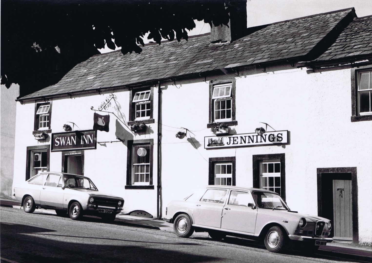
Kirkgate 56 Swan Inn c 1980. The door to the right of the Jennings sign was originally a poor house endowed in 1760 as a hospice for six poor widows or unmarried women who were above 60 years of age. The building is now part of the Swan Inn. Note the chestnut tree at the end that had to be demolished because it was diseased. c 1980
Kirkgate 56 Swan Inn c 1980. The door to the right of the Jennings sign was originally a poor house for seven widows, connected with All Saints Church. The building is now part of the Swan Inn. c 1980
Kirkgate 56 Swan Inn, a bit older looking than it is now. c 1899
Kirkgate 67 Quaker Meeting House
Kirkgate Windmill Lane the large building was the wool store for the business that also had Fletchers knacker yard and tannery in St Helens Street and was demolished c 1934 with the smaller attached building to widen Windmill Lane. Note the gas lamp in the middle of the road before traffic increased.
in 1856 a new five acre area was dedicated to be Cockermouth Cemetery. However, people had to walk up Kirkgate, then down Skinner Street then up the narrow bit of road known as Scarwell Brow on Skinner Street to continue on Lorton Road to the new cemetery. An interesting historic route is to not turn onto Lorton Road but go down Skinner Street and note at the bottom is an archway under the “new road” leading to Little Mill that is now converted into a private house. Continue up Skinner Street to join the “new” section of Lorton Road and continue to the next bridge that goes over the former Cockermouth Keswick Penrith Railway [CK & P] which is now the greenway going from behind Aldi past Woodville Park, continues east past the war memorial, past the Sidings over the old railway bridge, by Strawberry Grange estate to join the Strawberry How road.
Note that when you go under the bridge under Skinner Street you are in an area that once had tanneries to process animal hides into leather (long demolished) , and you can imagine the amount of work and employment in the Little Mill and the tanneries. It is possible that Skinner Street may have been named from butchering and skinning the animals, but your research is required.
c 1930
Kirkgate top section leading to Windmill Lane on left The Fletcher Cottage and wool store have been demolished to make access for Slatefell Estate c1934.
On the right edge of the photo and on this screen grab is the gable end of Diamond Cottages on Lorton Road (where Eric Cass was born) This section of Lorton Road between Kirkgate and the start of the cemetery was built about 1862 because in 1856 a new five acre area was dedicated to be Cockermouth Cemetery. However, people had to walk up Kirkgate, then down Skinner Street then up the narrow bit of road known as Scarwell Brow on Skinner Street to continue on Lorton Road to the new cemetery.
An interesting historic route is to not turn onto Lorton Road but go down Skinner Street and note at the bottom is an archway under the “new road” leading to Little Mill that is now converted into a private house. Continue up Skinner Street to join the “new” section of Lorton Road and continue to the next bridge that goes over the former Cockermouth Keswick Penrith Railway [CK & P] which is now the greenway going from behind Aldi past Woodville Park, continues east past the war memorial, past the Sidings over the old railway bridge, by Strawberry Grange estate to join the Strawberry How road.
Note that when you go under the bridge under Skinner Street you are in an area that once had tanneries to process animal hides into leather (long demolished) , and you can imagine the amount of work and employment in the Little Mill and the tanneries. It is possible that Skinner Street may have been named from butchering and skinning the animals, but your research is required.
Note there are pictures in this collection of Skinner Street tannery at the bottom of the road to the right of the advertising hoardings, then left under todays road archway, and the picture shows children on the cobbled path outside their house. 1936
Kirkgate Windmill Lane the large building was the wool store for the business that also had Fletchers knacker yard and tannery in St Helens Street and was demolished c 1934 with the smaller attached building to widen Windmill Lane. Note the gas lamp in the middle of the road before traffic increased and the interesting car (what sort was it?) approaching the person leaning with his bike against the gas lamp post. c 1930
Kirkgate top section leading to Windmill Lane on left The Fletcher Cottage and wool store have been demolished to make access for Slatefell Estate c1934. On the right edge of the photo and on this screen grab is the gable end of Diamond Cottages on Lorton Road (where Eric Cass was born!) The section of Lorton Road between Kirkgate and Scarwell Brow was built about 1862 after the cemetery had been built in 1856.
in 1856 a new five acre area was dedicated to be Cockermouth Cemetery. However, people had to walk up Kirkgate, then down Skinner Street then up the narrow bit of road known as Scarwell Brow on Skinner Street to continue on Lorton Road to the new cemetery. An interesting historic route is to not turn onto Lorton Road but go down Skinner Street and note at the bottom is an archway under the “new road” leading to Little Mill that is now converted into a private house. Continue up Skinner Street to join the “new” section of Lorton Road and continue to the next bridge that goes over the former Cockermouth Keswick Penrith Railway [CK & P] which is now the greenway going from behind Aldi past Woodville Park, continues east past the war memorial, past the Sidings over the old railway bridge, by Strawberry Grange estate to join the Strawberry How road.
Note that when you go under the bridge under Skinner Street you are in an area that once had tanneries to process animal hides into leather (long demolished) , and you can imagine the amount of work and employment in the Little Mill and the tanneries. It is possible that Skinner Street may have been named from butchering and skinning the animals, but your research is required.
Note there are pictures in this collection of Skinner Street tannery and children on the cobbled path outside their house.
Photo Google Maps
The toll cottage on Kirkgate was moved 18xx to be beside Rose Cottage on Rose Lane, past the entrance to the cemetery on Lorton Road. Note the entrance to Long Croft is very narrow and led to open fields on Slate Fell. When it was decided to put houses on Slate Fell, the road had to be widened by removing the building jutting out into Skinner Street, see photos of this building which was Fletchers wool store. Note also that the narrow road to Skinner Street continues towards Lorton, here it is signed to Keswick. This narrow street dipped down then up and when the new cemetery was built a new section was built above it that is now the normal road, but you can still go down the old Skinner Street.
Map from Bradbury
In 1839 there was no bridge across the Cocker from Lorton Street. The only way to get to the Lorton valley was to go up Main Street, into Market Place, turn right into Kirkgate and continue onto Skinner Street. The only other bridge into Cockermouth was the Gote bridge.
In 1887 for Queen Victoria’s Jubilee, a new bridge was built across the Cocker at Lorton Street and if you stand at the Methodist church and look at the terraced row of houses opposite, the house nearest the bridge has on its right corner the commemorative stone engraved with “Ashgrove 1889”. It is reasonable to assume that these well built houses were constructed at the same time as the Queen Victoria Jubilee bridge.
The intention of this road was to be an alternative and much better route to Lorton and Keswick than turning up Kirkgate from the Market Place (today that turning is still notorious). However this new road would have had to join the narrow Skinner Street, but fortunately in 1862 a new section of Lorton Road was built that is raised above Skinner Street and a section of Skinner Street was demolished to allow the new road from Jubilee bridge to join and bend sharp right through the gap that has been made in the row of cottages, then continue towards Lorton.
On Bradbury’s map note that the L is where the new road to Lorton goes. An intriguing name on Bradbury’s map is “God’s Providence Yard” that begs an explanation
Kirkgate top section here extends down Skinner Street over Tom Rud Beck before the new raised Lorton Road was built. Note on the right foreground the road is named Victoria Road because it was built with the new Jubilee Bridge over the Cocker as part of the celebration of Queen Victoria’s Jubilee in 1887. This new bridge and road joined the Lorton Road after part of the row of houses at the top of Kirkgate were demolished to make a gap for the road. That row of houses would have continued down the right side of this photo. Crossing Tom Rud Beck may have been a ford or narrow bridge.
Kirkgate All Saints Church Rooms was the old Grammar School attended by William Wordsworth, Fletcher Christian (Mutiny…) now converted into holiday let.
Kirkgate All Saints Old Grammar School built in 1676 demolished in 1895. This was the predecessor of All Saints church rooms and was the Grammar School attended by William Wordsworth, Fletcher Christian (mutiny of the crew of the Bounty). New church rooms were built on the same site and were sold to be converted into a luxurious holiday let.
Kirkgate All Saints Old Grammar School built in 1676 demolished in 1895. This was the predecessor of All Saints church rooms and was the Grammar School attended by William Wordsworth, Fletcher Christian (mutiny of the crew of the Bounty). New church rooms were built on the same site and were sold to be converted into a luxurious holiday let.
Rear view of Kirkgate All Saints Old Grammar School built in 1676 demolished in 1895. This was the predecessor of All Saints church rooms and was the Grammar School attended by William Wordsworth, Fletcher Christian (mutiny of the crew of the Bounty). New church rooms were built on the same site and were sold to be converted into a luxurious holiday let.
Kirkgate All Saints Old Grammar School 1676 – 1895 before demolition 4 1894 p1
Rear view of Kirkgate All Saints Old Grammar School built in 1676 demolished in 1895. This was the predecessor of All Saints church rooms and was the Grammar School attended by William Wordsworth, Fletcher Christian (mutiny of the crew of the Bounty). New church rooms were built on the same site and were sold to be converted into a luxurious holiday let. This photo must have been hand coloured because colour photography was not invented at the time of the demolition.
Kirkgate All Saints Old Grammar School built in 1676 demolished in 1895. This was the predecessor of All Saints church rooms and was the Grammar School attended by William Wordsworth, Fletcher Christian (mutiny of the crew of the Bounty). New church rooms were built on the same site and were sold to be converted into a luxurious holiday let. A realistic tinting of the monochrome photo of 1895.
Kirkgate Bitter End pub upper from All Saints churchyard c 1990
Kirkgate at the end of Mackreth Row with John Street to the right. Behind the photographer is Kirkbank. Note the difference between this photo and today’s nicely renovated gable end of this house that has three new windows. Today the shed wall on the left has been rebuilt. This area today is a delightful quiet walk above the Cocker and a credit to house renovators.
Kirkgate used to go up the hill from Bitter Beck, past the Quaker Meeting House and bend to the right, following the line of the terraced houses on the right where there is an area sometimes uses for parking. Kirkgate then had a row of houses that were demolished so that the road from Lorton Street could come through the gap. Before the houses were demolished, Kirkgate continued downwards to what is now named Skinner Street. Go down that narrow road and you are on the old road out of Cockermouth. At the bottom of Skinner Street you would turn left to the tannery, shown in the photo, now demolished, this was one of the tanneries on Skinner Street.
There were tanneries on St Helens Street and below the castle on the Derwent were tanneries, other pictures show the tannery buildings and houses below the castle.
If you continue up Skinner Street the incline brings you to Lorton Road.
The elevated part of Lorton Road was made so that it could cross Tom Rud Beck and the newly built railway that was built above Cockermouth. The railway line is now the greenway and cycle route 71.
Lorton Road with Skinner Street on left before the new houses on left built.
The elevated road on the right did not exist until 1862, before then the route was on the left; from Cockermouth to the Lorton valley was from Market Place, up Kirkgate, down the road on the left and up to where the photo is taken, crossing Tom Rudd Beck at the bottom.
In 1862 the elevated road on the right was constructed from the top of Kirkgate that not only went over Tom Rudd Beck but has a tunnel to Little Mill.
In 1887 as part of Queen Victoria’s Jubilee celebrations, a new road bridge was built from Lorton Street, over the Cocker, and the road from this new bridge was called Victoria Road. For the new road to join this road in the picture, houses at the top of Kirkgate were demolished. From Victoria Road the section of road on the left to where the photographer is was renamed Skinner Street.
Kirkgate used to go up the hill from Bitter Beck, past the Quaker Meeting House and bend to the right, following the line of the terraced houses on the right where there is an area sometimes uses for parking. Kirkgate then had a row of houses that were demolished so that the road from Lorton Street could come through the gap. Before the houses were demolished, Kirkgate continued downwards to what is now named Skinner Street. Go down that narrow road and you are on the old road out of Cockermouth. At the bottom of Skinner Street you would turn left to the tannery, shown in the photo, now demolished, this was one of the tanneries on Skinner Street.
There were tanneries on St Helens Street and below the castle on the Derwent were tanneries, other pictures show the tannery buildings and houses below the castle.
If you continue up Skinner Street the incline brings you to Lorton Road.
The elevated part of Lorton Road was made so that it could cross Tom Rud Beck and the newly built railway that was built above Cockermouth. The railway line is now the greenway and cycle route 71. c 1900
The toll cottage on Kirkgate was moved 18xx to be beside Rose Cottage on Rose Lane, past the entrance to the cemetery on Lorton Road. Note the entrance to Long Croft is very narrow and led to open fields on Slate Fell. When it was decided to put houses on Slate Fell, the road had to be widened by removing the building jutting out into Skinner Street, see photos of this building which was Fletchers wool store. Note also that the narrow road to Skinner Street continues towards Lorton, here it is signed to Keswick. This narrow street dipped down then up and when the new cemetery was built a new section was built above it that is now the normal road, but you can still go down the old Skinner Street.
Kirkgate extended to Skinner Street – here three children on cobbled path outside their house
Kirkgate 31 The old building at the top right is Rope Walk now demolished accessed from Kirkgate cobbles. The buildings being demolished were at the lower end of Kirkgate. c 1950