Gote Road Lowther Arms protrudes onto cobbled pavement by the gravel road with cartwheel tracks. Postman with his bicycle on left. Gable end of Hospice in centre of photo. Named Goat but today known as Gote Road.
A feature of market life which disappeared between the wars was the sale of Irish geese, landed at Silloth or Whitehaven after harvest time. They were driven through melted tar and then sand to prevent sore feet during their long marches. This ‘shoeing’ was done in Cockermouth at the foot of Gote Brow, near the entrance to ‘Senhouse Park’.[30] They were sold as they passed through villages or to and those intended for the Cockermouth market on Monday usually reached the town on Saturday to be rested in Deer Orchard or the field where the hospital now stands. Bradbury chpt 18
Gote Road shows the Lowther Arms serving Lion Ales, one of two of Cleator Moor brewery.
The building nearest the photographer has a bricked up doorway, next to what appears to be a shop window. Compare with the photo below of today.
Gote Road. The Lowther Arms built 1741 is now a private house and the end property is now rebuilt.
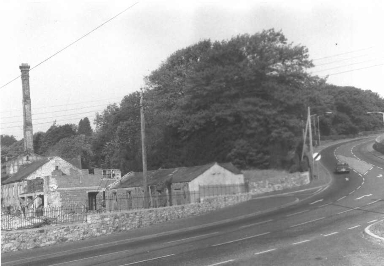
Gote Road. The Esso garage that later became car repair workshop and currently is a car sales place. Opposite is the Lowther Arms pub.
In the centre of the photo is the hospice with the windows appearing black because there was no glass – it was open to allow the flax to dry.
Above the roof of the Esso is the chimney on the Papcastle road and was the waterworks chimney for pumping water to the header tank on Tallentire Hill to supply drinking water to Maryport.
Gote Road shows the state of houses before renovation, and the chimney of the pumping station on the Papcastle road that pumped drinking water to Maryport from a borehole beside the bend in the Derwent river.
Gote Road. The Lowther arms is on the right. In the centre is the building with no glass in the windows, used for drying flax that was wrongly known as the hospice.
Gote Road 5 to 35 with the entrance to Sandair, the cricket ground. In the distance note the black window openings of the flax drying shed.
Gote Road to Papcastle Junction Improvements
At the bottom of Gote Brow is the junction for the road to Papcastle and Seaton, before the days of the bypass. The Papcastle road was very narrow, blocked by buildings, and Gote Road was very narrow, as seen from this photo. Eventually James Walker factory would be built to the left of the photographer.
To widen the road, the block of houses in the centre of the photo were demolished. Also the single storey houses along the Papcastle Road were demolished and the road junction widened and the approach to Gote Brow made three lanes wide, with the potential for better road access to land on which James Walker factory was later built.
The tall chimney was from the pumping engine that took water from a borehole and pumped it to the top of Tallentire Hill header tank from where it supplied Maryport.
Gote Road looking towards Cockermouth's gas holder. The buildings in the centre of the photo and the low wall were demolished to improve road access to the James Walker factory, and the turning for Seaton, also for better access eventually to the new bypass.
Gote Road with the turning for Papcastle Road on the right by the gable end of the house. On the left is a wall where eventually James Walker factory entrance will be. Ahead are the allotment gardens, still there today. If you were to continue along the road you would cross Gote Bridge, on the other side of the Derwent is the gasworks gas holder. Note the Lorton fells in the distance. The buildings on the right will be demolished and replaced with a bungalow and a large garden.
Gote Road bending to go up Gote Brow. The low buidings in the centre were demolished and the gable end with the arched windows is the hospice that was the original drying shed for Low Gote Mill and later for Harris Mill now renovated to a private house. On the right of the picture the grey house is actually on the left of the road and was demolished and the road built over that site to make a smoother curve to ascend Gote Brow. The white building on the right is High Gote Mill that is now part of Lawsons Haulage depot and still has some indication of mill actovities
Gote Road descends down Gote Brow at the top of the map, passes the turning to Papcastle at Goat Mills where today on the right side is James Walker factory, and Goat Mills on the right is Lawsons Haulage yard.
Sandair is the local name for the land enclosed by the curve of the Derwent river and today includes the land shown here as a tree nursery; this area is now Cockermouth Cricket ground. Carnivals and public events once took place here, as these accompanying photos show. A hydrogen filled balloon took off from here, I think that there may be an aerial photo on this website that was taken from the balloon.
The Lowther Arms Inn is not a private house and retains the attractive panel on the front of the house that once had the name painted on it. Goat Well and the stream Goat Dub are no longer evident. The road to Papcastle and buildings by the junction were demolished to widen the junction and a new bungalow built there. The building beside the word Spital of Spital Ing Lane had window openings without glass so the air could pass over the newly woven linen that was manufactured in Goat Mills by the Harris family before they built the Derwent Mills. On the bottom right corner is Bleach House naming unknown, though when the Derwent Mills was built by the Harris family, they continued to make linen from flax plant fibres and this cloth retains water from its manufacture so requires drying and photos on this site show the linen spread out on adjacent greens, to dry in the sun and perhaps to be bleached in the sun, perhaps thus giving the name of Bleach House to the building.
On the left bank of the Derwent is Fitz Mill that can be seen in the background of festivities on Sandair. This once had a weir with a fish pass but it was all demolished, though some of the large stone blocks can still be seen on the right bank in the undergrowth, past today’s fishing shed. This area used to be one of Cockermouth’s refuse disposal places, even though the river regularly washes over the surface. Photos of Fitz Mill show a chimney and further research may explain if the weir was for water supply rather than water power.
After one of the major floods of Cockermouth in recent times some “flood attenuation tanks” were built, one in Main Street at the cross road with Station Street and High Sand Lane, and another at the bottom of the Goat, approximately where the word Goat is printed in bold. One of the engineers working on this said the intention is to keep the tanks empty and catch a sudden increase so the water drainage system is not overwhelmed.
This map is from National Library of Scotland NLS 121144250 https://maps.nls.uk/view/121144250