Mills - Fitz Mill on Derwent

Mills - Menu
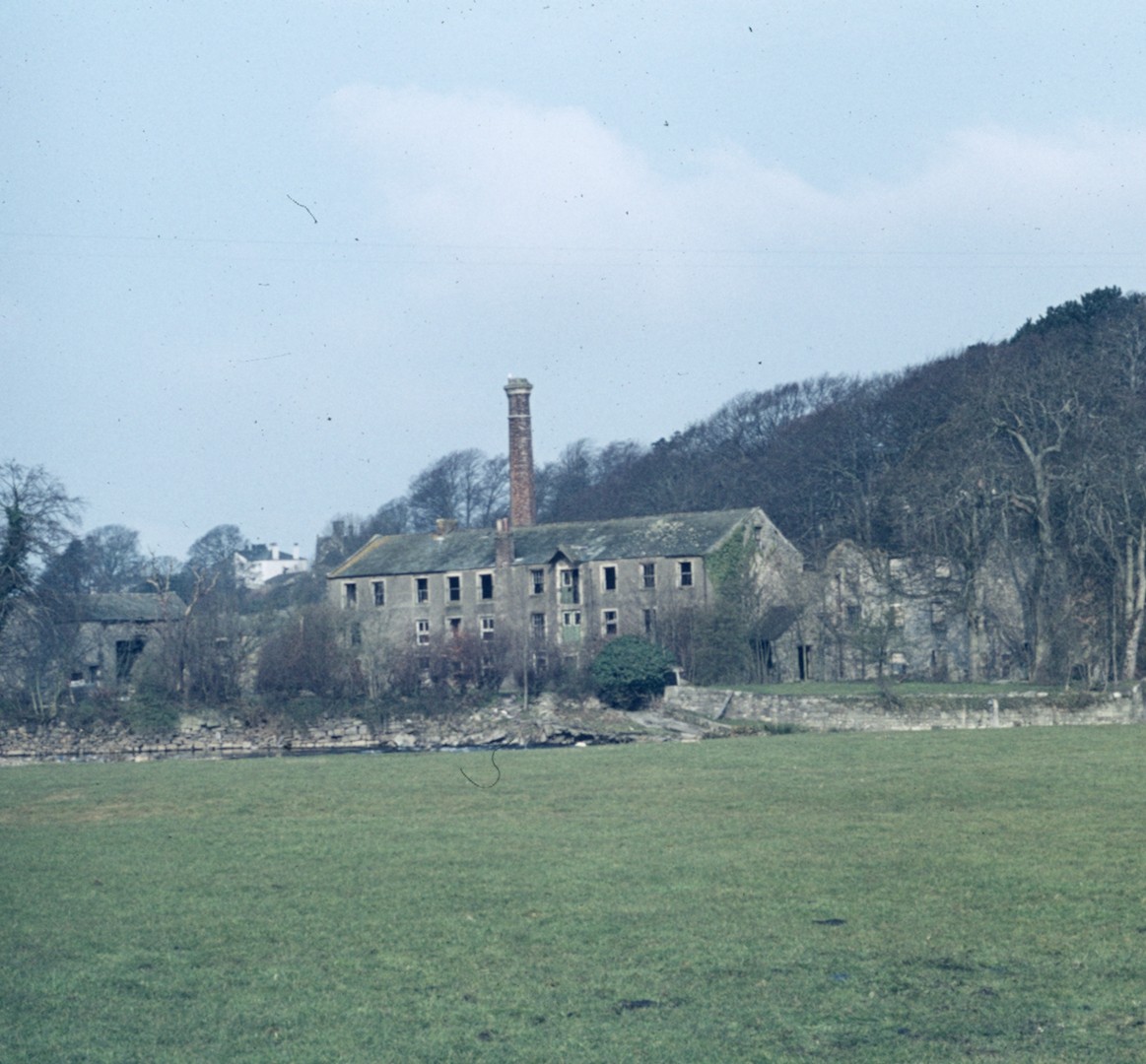
Fitz Mill Bradbury Chapter 29
The inhabitants of the Gote found work not only in the various Gote mills but also in the Fitz Mill complex across the Derwent. A variety of activities took place in the Fitz Mills, which belonged to the Senhouse family. Wood gives nothing beyond ‘Fitz Mill. Capt. Senhouse’ in 1832 and the first OS map 30 years later marks it ‘Flax’. A map shows a corn mill in 1774. [Bradbury 13]
In 1883 Richard Senhouse leased [14] to Allan Banks of Cockermouth the cottage, garden, dye house, drying loft, bleaching house, bleaching green and out offices at Fitz Thread Mill for £1-4s 8d. a month. The mill and engine house were not included. In March 1893 Banks was given notice to quit and the following year the premises were leased to a syndicate for “manufacturing woollen goods and the spinning of carpet and other yams”. In the agreement (which did not include the bed of the Derwent and its fish and gravel) everything was listed in the greatest detail, even the number of wooden props supporting the floors. The document refers to the old mill, new mill, boiler house, engine house, dye house, store room, thread shop, old store room and old cottage. [15]
The syndicate, the Fitz Mill Co. Woollen Spinners, insured their part of the premises (some parts were empty) for £1100, paying a premium of £18-2s-0d. The policy mentions two and three storey buildings containing a willying house (one willy machine and one testing machine); rooms for carding, scribbling, mule spinning, reeling and twisting; wool, shoddy and cow hair stores; a dwelling house; a gearing house; a steam engine house; water wheel; etc. [16]
The venture was apparently very short-lived, the insurance premiums telling the story. In July 1895 the policy described the mill as “silent and at rest”, the premium being reduced to £2-15s-0d. In August 1896 the policy stated the “mill being silent it is also empty” and the premium was down to £1-7s-6d. On a map of 1900 it was labelled ‘disused’ and three years later part of the upper floor was being used by Wilkinson Jennings as a paper store. [17]
The salmon pass at the Fitz was designed by Thomas Rook, who became an important man in the fisheries office on Cocker Bridge. [18] The mill is said to have made an interesting contribution to town life when, for a special occasion, one of the wheels generated electricity which lit fairy lights in Main Street. [19]
Fitz Mill on the inner bend of the Derwent is now demolished. The remains of the weir on the left of the photo have also been demolished but large stones remain on the right bank.
The location is accessed down the track at the end of Lakes Home Centre car park, continue to the river bend where, on the opposite bank, you will see the building that had been a water mill with the facimile of a water wheel embedded in its wall.
See Bradbury Chpt 29. p2

Fitz Mill on the left bank of the Derwent ceased to be a mill around 1900.
Goat Mills (Corn) at the top of this map is the first mill of the Harris family before they built Derwent Mill and known as Low Gote Mill.
The old watermill building has been tastefully modernised into dwellings in 1974 with the waterwheel respectfully preserved at the side of the building.
On the right of the Goat is also shown as Goat Mills and is known as High Gote Mill, now Lawson Haulage, previously Harkness millers of cereals. Both High and Low Gote mills were powered by waterwheels fed by a mill race that can be seen on the middle right of the photo and extended to its source opposite Cockermouth Castle.

Fitz Mill on the inner bend of the Derwent to the west of Gote road, here being demolished. The site can be accessed via the lane beside the car park of Lakes Home Centre.

The photo is taken from Spital Ing Lane which is the narrow lane starting from where Gote Road swings to the right with the grassed area, at that point is Spital Ing Lane to the left.
On the left edge centre you see a slightly elevated bank – this is the left bank of the Derwent which flows to the right towards the building with the square chimney and then the river bends abruptly left.
At the bend is the square chimney and building of the pumping house that took water from a borehole and pumped it 220 feet higher to filter beds at the top of Tallentire Hill above Bridekirk from where it flowed by gravity to supply drinking water to Maryport.
On the right of Maryport’s water supply is the building that was the lower part of the Low Gote Mill complex that had two wheels that had been powered by a water channel that originated opposite Cockermouth Castle.
The building we see on the right of the photo was demolished, leaving another part of the mill complex above the building seen in this photo – that was converted to dwellings in 1978/79 and the conversion preserved the water wheel.
On the left of the photo above the raised bank (the left bank of the Derwent) is the old Fitz Mill on the inner bend. This ceased to be a mill around 1900.

Fitz Park rugby ground looking north over the railway line that ascends to Cockermouth station. The chimney centre left is by the right bank of the Derwent river, powering the pumping station that took water from a borehole to pump to the top of Tallentire Hill for Maryport. The chimney on the far left is for Fitz Mill that was on the left bank of the Derwent on the sharp bend, where once there was a weir to provide for the mill, the site is accessed to the right of Lakes Home Centre car park.

Fitz Mill, now demolished, on the left side of the bend in the Derwent, opposite the hill that leads to Papcastle, ie opposite Low Gote Mill and Maryport water pumping station.
Originally, Fitz Mill was water powered by the Derwent with this weir raising the head of water to power the machines. Eventually Fitz Mill and the weir were demolished.
Fitz Mill on the inner bend of the Derwent now demolished.
The location is down the track at the end of Lakes Centre car park, continue to the bend – over the river and opposite is the renovated building that had been a water mill and has the facimile of a water wheel embedded in its wall. This location has nothing but rubble in its place.
The remains of the weir on the left has been demolished. Taken from the Sandair cricket ground. See Bradbury Chpt 29. p2

Fitz Mill Derwent opposite Papcastle road. Fitz Mill on right is on the inner bend of the Derwent to the west of Gote road, here being demolished. The site can be accessed via the lane beside the car park of Lakes Home Centre.

Fitz Mill on right is on the inner bend of the Derwent to the west of Gote road, here being demolished. The site can be accessed via the lane beside the car park of Lakes Home Centre. On the left of the photo, on the right bank of the Derwent is the pump house on Papcastle Road, this pumped water from a borehole to filter beds at the top of the Tallentire Hill to supply Maryport. The elegant square section chimney was demolished in 1974, but the borehole apparently remains according to Bernard Bradbury’s 1990 booklet Cockermouth in Pictures 1 Industry. This is located on the bend of the Derwent other photos show a weir on the right of the mill in the foreground.

Fitz Mill Derwent opposite Pump House on Papcastle road. Fitz Mill Derwent Fitz Mill taken from the Pump House on the Papcastle road from the Gote. This ceased to be a mill around 1900. The photo is taken from the right bank with Papcastle road behind.

Fitz Mill Derwent Fitz Mill taken from the Pump House on the Papcastle road from the Gote. This ceased to be a mill around 1900. The photo is taken from the right bank where the pump house for Maryport’s drinking water borehole was, with its square chimney (built 1810 demolished 1974). Also behind the photographer is the first mill of the Harris family before they built Derwent Mill – the old watermill building has been tastefully modernised into dwellings in 1974 with the waterwheel respectfully preserved at the side of the building.

Fitz Mill on the Derwent bend opposite Low Gote Mill off Papcastle road. From Gote road there is a driveway to the now renovated Low Gote Mill with its wheel embedded as part of the tasteful renovation. From its car parking area the bend in the Cocker is seen. To the left, upstream, was a dam that provided water power to the mill building seen in the bend of the river. The dam and mill are now demolished. The dam had been partly damaged by a previous flood.

Fitz Mill with its chimney by the Derwent taken from Sandair, today Cockermouth cricket ground. The crowds on this public field were probably attending Cousin Charley’s Day celebrations in about 1901, see other photos, one of which shows the hot air balloon taking off with crowds, and the same mill building behind. In the collection of photos there is an aerial photo of Cockermouth dated 1901 which was taken from that hot air balloon.

Cousin Charley’s (hydrogen) Balloon. Fitz Mill with its chimney by the Derwent taken from Sandair, today Cockermouth cricket ground. The crowds on this public field were probably attending Cousin Charley’s Day celebrations in about 1901, see other photos, one of which shows the hot air balloon taking off with crowds, and the same mill building behind. In the collection of photos there is an aerial photo of Cockermouth dated 1901 which was taken from that hot air balloon.

Fitz Mill Derwent Fitz Dam in the flood of 1918.
Across the centre of the photo you see the water flowing over the dam which was put there to raise the level of the Derwent so that a channel of the Derwent could be diverted to power the waterwheel of Fitz Mill on the inside bend of the Derwent. The site has been demolished but can be accessed down the lane that is at the side of Lakes Home Store on the left bank of the Derwent.
The line of trees on the left of the photo (right bank of the Derwent) shows a small building that was likely part of the fish bypass, photos elsewhere of the substantial concrete creation. Beyond these trees is the wide level area that has been turned into a pond by the overflow of the Derwent (repeated in 2000s) – at this time in 1918 the area called Sandair was, and still is, the Cockermouth Cricket ground.

Fitz Mill Derwent was where the gravel is on the inner bank. The grassed area on the right of the Derwent is Sandair, Cockermouth Cricket ground where photos of 1901 show Cousin Charley and his hot air balloon taking off from.

Fitz Mill Derwent Fitz Dam, note on the near left edge of the photo is the concrete wall of the fish pass (see other photos) because the dam restricted the flow of the Derwent.
At a later time the dam and fish pass were demolished, leaving only rubble rapids in the Derwent at this bend of the river that can be accessed either from the fishing track behind the cricked ground, or via the farm track by Lakes Home Store.
Across the centre of the photo you see the water flowing over the dam which was put there to raise the level of the Derwent so that a channel of the Derwent could be diverted to power the waterwheel of Fitz Mill on the inside bend of the Derwent. Obviously at a later time steam powered machinery was used evidenced by the chimney.

The Derwent flows under Gote bridge, past Lakes Home and flows towards the steep bank at Papcastle Road before bending sharply, and at this point used to be Fitz Mill, now demolished. The mill had originally been water powered with the height of the Derwent raised by a dam, and these photos show the construction and use of the dam and the fish ladder for fish to bypass the dam, designed by Thomas Rook, who became an important man in the fisheries office on Cocker Bridge.

The Derwent flows under Gote bridge, past Lakes Home and flows towards the steep bank at Papcastle Road before bending sharply, and at this point used to be Fitz Mill, now demolished. The mill had originally been water powered with the height of the Derwent raised by a dam, and these photos show the construction and use of the dam and the fish ladder for fish to bypass the dam, designed by Thomas Rook, who became an important man in the fisheries office on Cocker Bridge.

The Derwent flows under Gote bridge, past Lakes Home and flows towards the steep bank at Papcastle Road before bending sharply, and at this point used to be Fitz Mill, now demolished. The mill had originally been water powered with the height of the Derwent raised by a dam, and these photos show the construction and use of the dam and the fish ladder for fish to bypass the dam, designed by Thomas Rook, who became an important man in the fisheries office on Cocker Bridge.