Cockermouth second workhouse built 1840-43 photo taken circa 1912. In WW2 evacuees were billeted there and the buildings were demolished in 1947/48 and Fitz View and Farifield View flats built. The Fairfield in foreground from Mitchells horse sale photo. c 1912 p2
Streets Menu
Click a pic for slideshow (Esc returns to this screen)
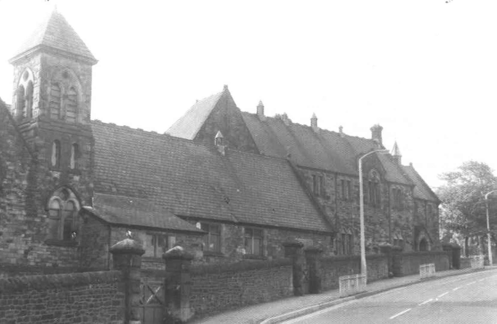
Christchurch Terrace Gallowbarrow opposite Fairfield School c 1950
Gallowbarrow with Fairfield school and Christchurch looking towards Wordsworth House note this is before the pedestrian crossing. c 1950
Gallowbarrow rail bridge being filled in for what is now Sullart Street car park which is now at the level of the bottom of this bridge. On the other side of this bridge is the traffic light junction and the mountain rescue HQ 1985
Gallowbarrow rail bridge being filled in. To the left is now the recycling bins and to the right was the old railway station and now The Sidings and the Mountain Rescue HQ 1985
The A5086 road into Cockermouth comes down Lamplugh Road and here crosses the bridge to Gallowbarrow, over the disused railway which closed in 1966. At first the bridge was strengthened as shown here. But at a later time this main entrance into Cockermouth from the A66 had heavy traffic so eventually the bridge was strengthened by infilling, see other photos. In the foreground the cutting of the railway was also filled in to make a new surface half way up the parapets that became Sullart Street car park with its recycling bins near the bridge parapets. c 1985
Station Road Cockermouth railway bridge after closure in 1966, after strengthening supports before being filled in. The road across is to Egremont A5086. The houses on the left are the bottom of Fernbank. The track towards us is now the site of the Cockermouth Mountain Rescue buildings. c 1970
The A5086 road into Cockermouth comes down Lamplugh Road and here crosses the bridge to Gallowbarrow, over the disused railway which closed in 1966. At first the bridge was strengthened as shown here. But at a later time this main entrance into Cockermouth from the A66 had heavy traffic so eventually the bridge was strengthened by infilling. In the foreground the cutting of the railway was also filled in to make a new surface half way up the parapets that became Sullart Street car park with its recycling bins near the bridge parapets.
On the other side of this bridge is now the mountain rescue HQ 1985
This now has Cockermouth recycling bins but had been the railway track that went under a bridge where the bank of earth is, and Gallowbarrow road goes left down to Main Street. The railway closed in 1966 and later the bridge was filled in and track raised, eventually becoming Sullart Street car park and recycling centre 1985 p4
Gallowbarrow railway now Sullart Street car park DMU in snow. The railway closed in 1966, track was remove and the cutting filled in to make Sullart Street car park and recycling bins. This photo was taken in April 1966 shortly before closure and although there is an abundance of snow here in the morning, by early afternoon the snow disappeared when the last steam train arrived from Penrith, there is a photo of the last steam train in snow. c 1960 p3
Cockermouth second workhouse built 1840-43 photo taken circa 1912. In WW2 evacuees were billeted there and the buildings were demolished in 1947/48 and Fitz View and Farifield View flats built. The Fairfield in foreground from Mitchells horse sale photo. c 1912 p2
Sullart Street cottages before demolition to widen road that leads from Wordsworth House c 1960
Sullart Street 1 footbridge over railway is now the car park. On the right was St Joseph’s School which is now Sixth Form College. Today on the left of the lowered wall is Kirklands housing. c 1950
Sullart Street footbridge over Cockermouth railway before the bridge was demolished, the Gallowbarrow road bridge to the right was filled in and the bed of the railway is now Sullart Street car park. Millers chimney on left and Christ Church on right. c 1950
Sullart Street South Street corner. The shop of the corner used to be the tuck shop for Fairfield School, now converted to a private house. On the right the grey fronted row of houses were demolished to the second rounded archway to make way for modern flats. c 1950
Sullart Street South Street corner. The shop of the corner used to be the tuck shop for Fairfield School, now converted to a private house. 2024
Sullart Street aerial before building Wordsworth Court. The road has been widened by the demolition of Wordsworth Tavern in 1965 and the row of terraced houses shown by the rubble by the road. The roof of the Royal Assembly Rooms is parallel to Sullart Street and is now offices and flats called Anderson Court. In the middle of the photo on the left of the road is now Wordsworth Court and at the bottom of the photo is a building with its roof removed in the process of demolition. The fine building on the centre left with the rounded gable end was known as the Board Room and from 1930 was used by Cockermouth Rural District Council (it did not cover Cockermouth, Cockermouth Urban District Council supervised Cockermouth from the Town Hall). From 1955 to 1987 it was the HQ of Cumbrian Fire Service. The Inspector of Weights and Measures and the Registrar of Births Marriages Deaths had offices there. In the 1990s It was converted to be the Manor House Hotel. To the right of Sullart Street Stricketts Court which is about to be partly demolished and redeveloped. c 1970
Sullart Street before demolition of houses on left for Wordsworth Court with sweet shop on right loved by school children. The houses had no rear yard to hang their washing so washing was hung in the communal drying ground and the posts can be seen in the photo with the horse sale. Where was the washing done, was there a communal washing place. Note that the road at the bottom where it meets Main Street is so narrow, it is like the narrow entrance from Kirkgate into Market Place – so it was an obvious solution to demolish the sub standard houses to widen the road for modern traffic requirements. c 1940
Sullart Street 18 before demolition where Wordsworth Court is now c 1960
Sullart Street 18 before widening and Wordsworth Court c 1970
Sullart Street Crown Street demolition of houses to make way for Wordsworth Court. On the left you can see the edge of the advertising boards at the split of Sullart Street and Gallowbarrow
Sullart Street looking south towards “Pepperpot House” in the distant right before demoliton of most buildings on the right and removal of the advertising hordings ahead. Eventually Wordsworth Court will be built on the right. Behind the photographer Sullart Street descends to the Main Street Crown Street junction and here we see the road narrows to a single carriageway. So the row of houses on the right and the pub on the corner of Crown Street were demolished to widen Sullart Street.
South Street right Sullart Street left Stricketts Court behind with old cottages replaced now with modern flats. At the bottom of the picture, is a row of houses to be demolished to widen the road and later build Wordsworth Court. The buttress of Christchurch can just be seen on the extreme right. The corner is where today cars turn into the South Street that leads to Sainsbury store.
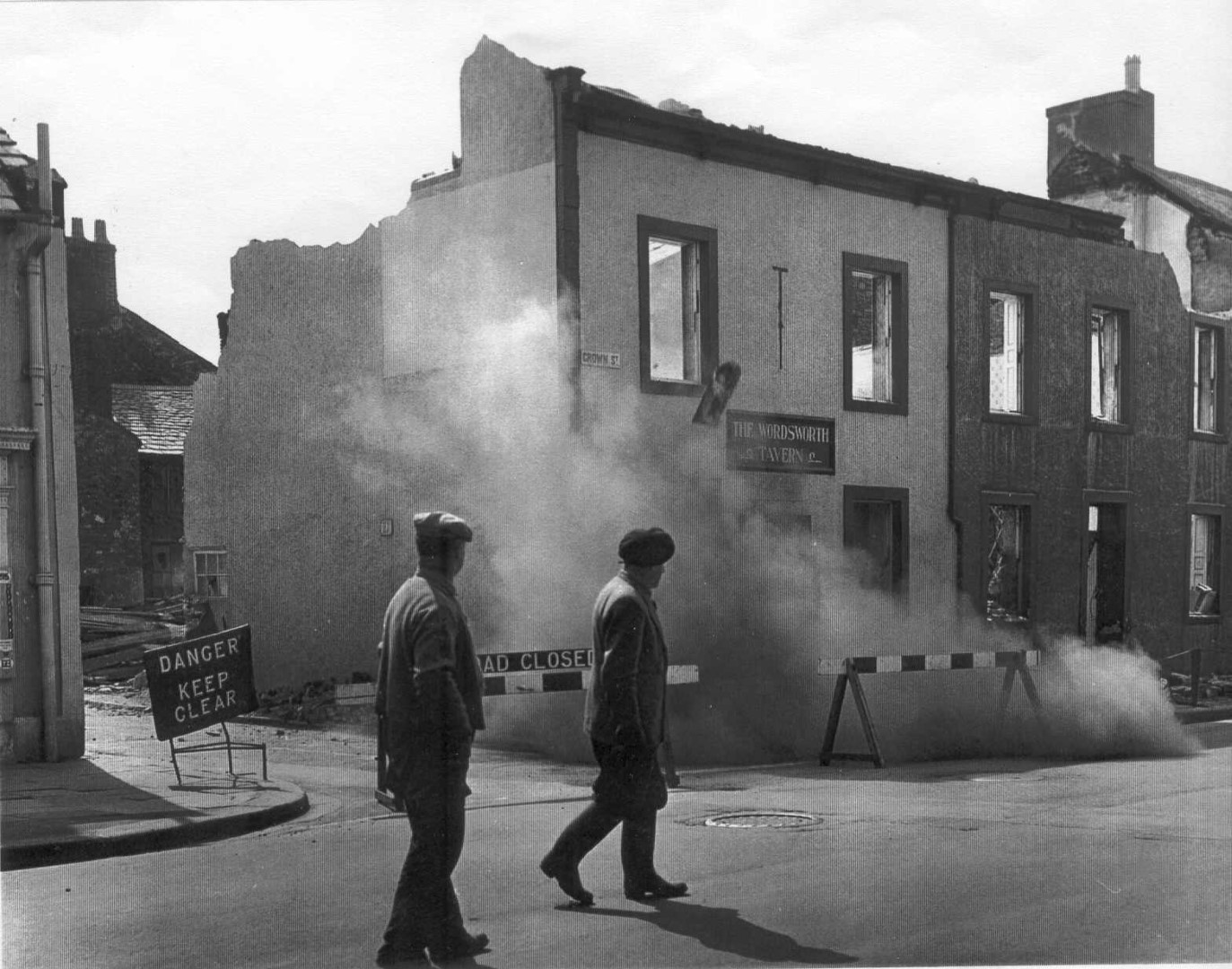
Sullart Street before widening and demolition of Wordsworth Tavern on the right in 1965
Sullart Street after demolition of Wordsworth Tavern that had been on the right so allowed road to be widened. Eventually Wordworth Court was built further up the road on the right. Note there is no pedestrian crossing or traffic “calming” humps. c 1975
Sullart Street before widening and demolition of Wordsworth Tavern on the right in 1965
Sullart Street 1 from Crown Street. Wordsworth Tavern which was on the right and had caused the road to be very narrow has been demolished. 1965
Sullart Street Crown Street corner had the Wordsworth Tavern making the entrance to Sullart Street very narrow, like the Kirkgate entrance to Market Place. This apparent casual demolition in 1965
Sullart Street Crown Street corner had the Wordsworth Tavern making the entrance to Sullart Street very narrow, like the Kirkgate entrance to Market Place. This apparent casual demolition in 1965
Sullart Street 1 from Crown Street. Wordsworth Tavern which was on the right and had caused the road to be very narrow has been demolished. 1965
Sullart Street demolition before Wordsworth Court built. Wordworth Tavern has been demolished on the corner in 1965, opposite the white Wordsworth House. The building with the large gable end will be eventually converted into flats and offices as Anderson Court, but the smaller building is to be demolished for the car park for Anderson Court. The buildings that had been by the side of the road hve gone and the wall and the building on the left is about to be demolished, all eventually to be Wordsworth Court. It is obvious that the terraced row of houses had no rear yard and thus took their washing to the communal drying area that is now Sainsbury car park and Fairfiled school. We can just see on the left beyond the wall is the curved gable end of the Manor House Hotel.
Another room in the town suitable for large gatherings was the Royal Assembly Room, behind the Royal Hotel which became Wild’s Garage in Crown Street, now converted to Anderson Court offices. Some other inns had smaller ‘assembly’ rooms.- Bradbury chpt 36
c 1970
Sullart Street 4 Crown Street demolition to widen access from Crown Street to Sullart Street. The Wordsworth Tavern had been demolished on the corner and the row of terraced houses demolished. 1965
Sullart Street 4 Crown Street after Wordsworth Tavern demolished to widen the road. The statue of Wordsworth Fountain has been moved from Harris Park.
Sullart Street Crown Street junction renovation of Royal Hall to become offices and dwellings. Another room in the town suitable for large gatherings was the Royal Assembly Room, behind the Royal Hotel which became Wild’s Garage in Crown Street, now converted to Anderson Court offices. Some other inns had smaller ‘assembly’ rooms. Bradbury chpt 36
Sullart Street ex Royal Hall ex Wilds garage renovation or demolition Wordsworth House in distance. c 1985
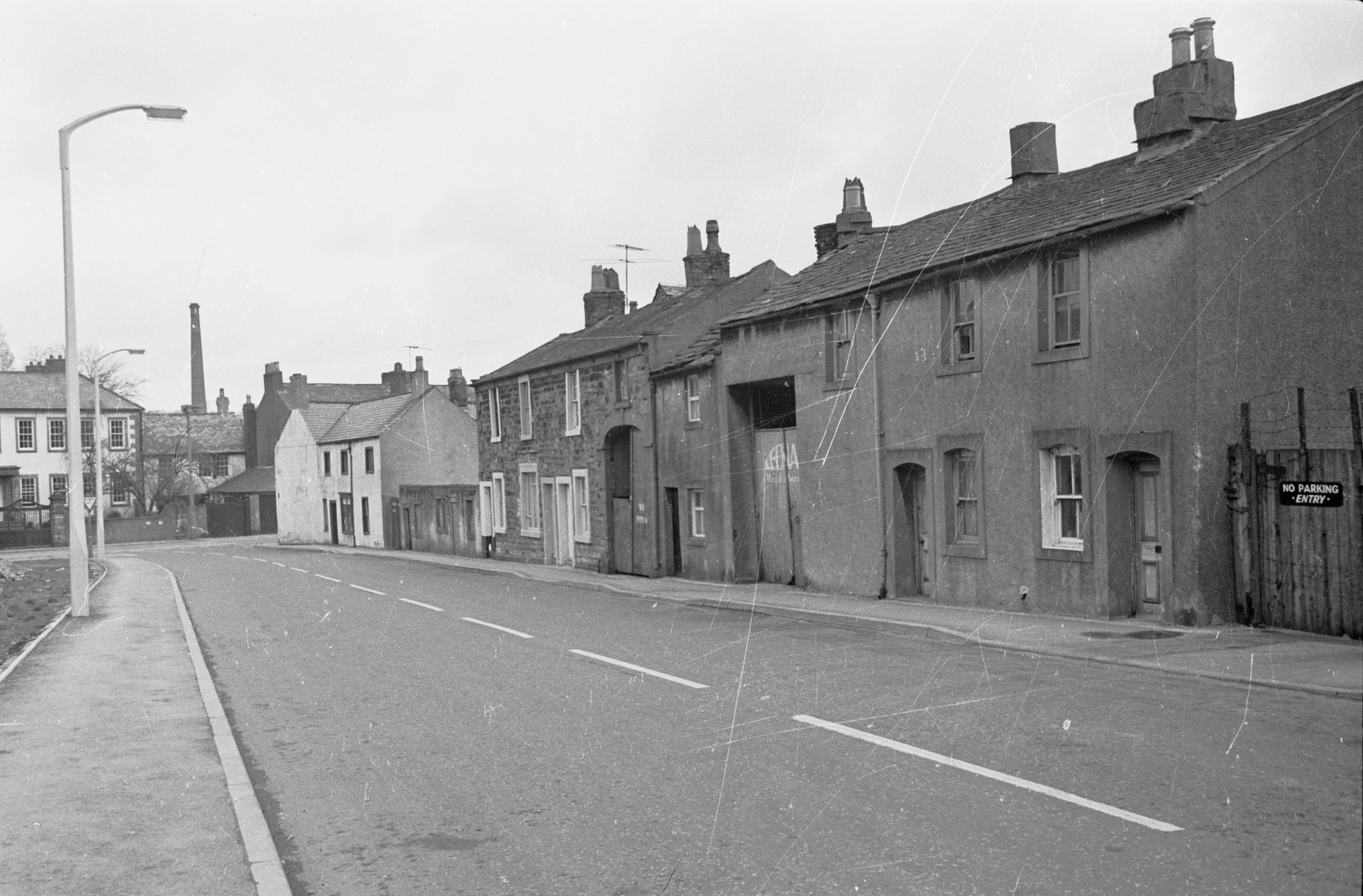
Sullart Street 43 taken from the junction with Gallobarrow. The demolished section on the right has a block of four flats built now. The wall beyond the house has the flat roof of the council depot office. The wall and area behind it is now Woodville Park estate. Sullart Street 43 is called Grecian Cottage because Grecian Villa is behind it. c 1950.
Sullart Street 43 looking north towards Main Street before demolition of most buildings on the left and removal of the advertising hordings on the right. Eventually Wordsworth Court will be built on the left where the lamp post is. As Sullart Street and Gallowbarrow on the right descend to the Main Street Crown Street junction the road narrows to a single carriageway so the row of houses and the pub on the corner of Crown Street were demolished to widen Sullart Street. c 1960
Sullart Street to Gallowbarrow after row houses on left removed for Wordsworth Court Google Maps 2024
Sullart Street to Gallowbarrow before row houses on lower left removed for Wordsworth Court and road widening. The high wall on the left continues to number 43 that still remains the others have been demolished. The high wall has now been demolished and the land behind, which had been the workhouse garden, later the County Council depot, is now the Woodville Park estate. c 1950
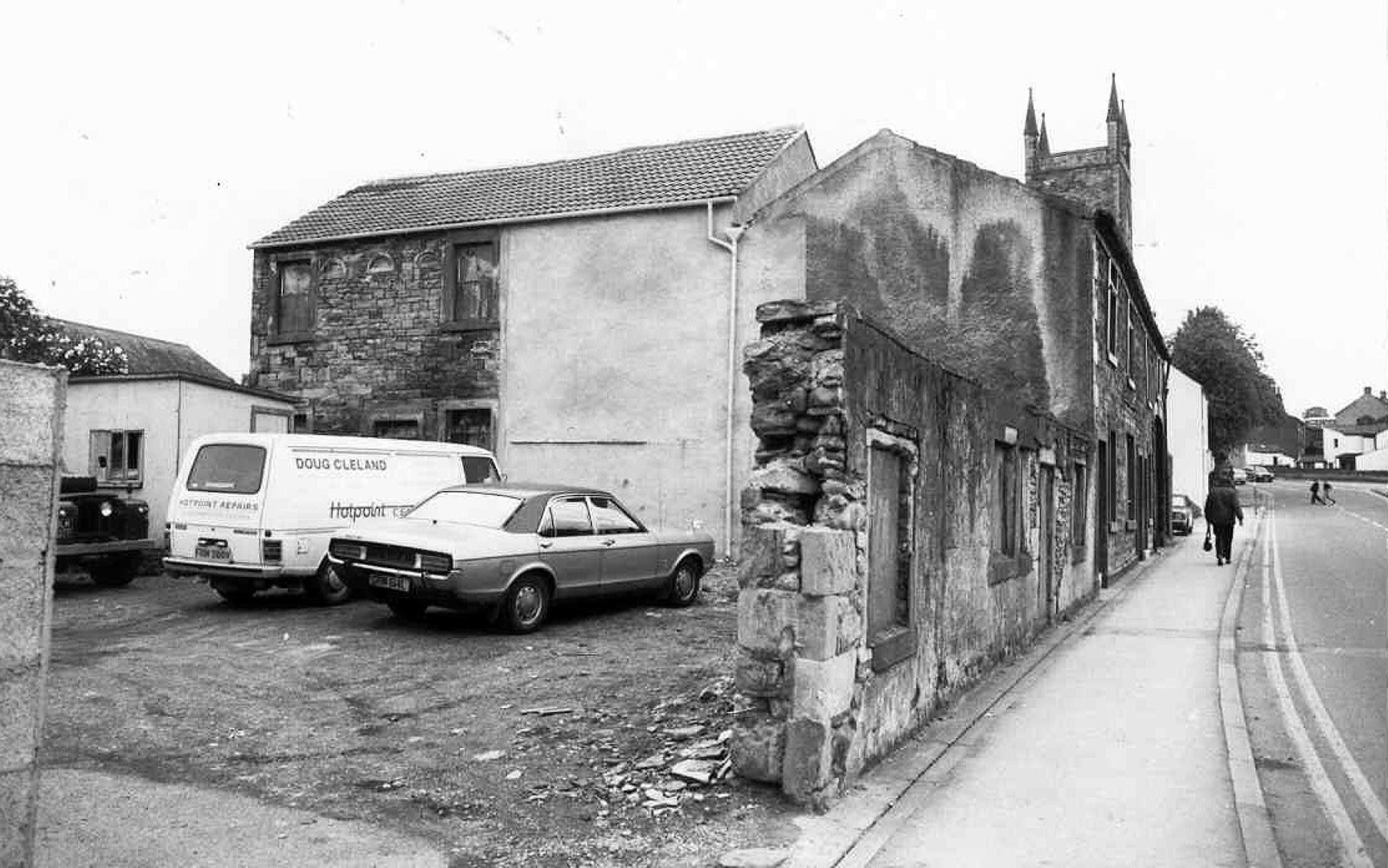
Sullart Street cottages before demolition small wasll being demolished to make way for their car park. Doug Cleland had the general electrical repairs on Main Street, not the furniture Cleeland. c 1970
Sullart Street before small building in centre was demolished to make an entrance to car parking behind the building. At one time the building was Keenans pot shop, various pots sold. c 1950
Sullart Street Main Street junction. On the right the archway has a date stone 1844 and would be the entrance for horse and carriages. To the left of the row is a small building that was demolished to allow parking space behind the renovated building. Derwent Mills chimney towers to the right of Wordsworth House. c 1970
Sullart Street sharing access to behind Stricketts Court. The building opposite had been the Royal Assembly Rooms and was converted to offices and flats in the 1984
Sullart Street some houses on right now demolished. Ahead is Wordsworth House with Millers chimney (demolished by Fred Dibnah). On the right foreground the grey fronted row of houses were demolished to the second rounded archway to make way for modern flats. On the left is now Wordsworth Court. c 1950
Sullart Street 8 Stricketts Court behind – note the arched feature under the roof c 1990 LEAD Technologies Inc. V1.01
Sullart Street Anderson Court building c 1970
Sullart Street is now on the right, but used to be on the left until in early 1900s the Ordnance Survey swapped the road names over to call the road on the left Gallowbarrow and the road on the right they called Sullart Street – but at the top of “Sullart Street” were the gallows in times past, approximately where the entrance to Parkside Avenue is. On the right foreground are cottages being demolished for the road widening and eventually Wordsworth Court to be built in 1985. In the right distance to the left of the tree is the shape of the corner building which is locally known as Pepper Pot House and was once used as an obvious landmark by the Mountain Rescue helicopters which landed on the playing field opposite.